Third in a series of posts about our work in the first quarter of 2024.
Since selecting Port Hilford Bay as the location for the sanctuary in 2020, we have conducted extensive qualitative and quantitative studies to ensure the site represents a suitable long-term habitat for whale residents.
Here is an overview of that work. It has included, but is not limited to:
- Acoustic studies of the marine environment;
- Water quality and water temperature analyses throughout all seasons;
- Impacts assessments during two hurricanes;
- Seasonal wave, tides and current measurements;
- Hydrodynamic modeling of the sanctuary waters, including with LIDAR, a remote sensing method used to examine the surface of the Earth;
- Migratory bird analyses;
- Flora and fauna review;
- Eel grass productivity and location analyses;
- Sediment sampling and analyses on land and in the marine environment.
In the video above, Charles Vinick, Executive Director, gives an overview of the additional environmental work and land management plan.
Water Quality
Studies conducted from 2020-2023 indicate that the water column above the seafloor is clean throughout the bay. Most recently, as part of our final round of environmental testing (ESA III), water samples were collected at select locations immediately above the seafloor and by a private diving contractor. Because of the historic gold mining that took place at the site in the 19th and early-20th centuries, these samples were analyzed by an independent laboratory for total metals concentrations relative to the Canadian Council on Ministers of the Environment’s Guidelines for the Protection of Marine Aquatic Life. Metals concentrations very slightly exceeded the limit (by 0.001μg/L) in only one of the 21 samples tested. Independent environmental consultants hired to obtain and interpret the data reported that these mercury concentrations were unlikely to be related to the former gold mining activity that took place at the site. Rigorous water testing will continue in perpetuity to ensure the environment remains clean and safe for the animals.
Sanctuary Lands Onshore
Samples taken by independent environmental consultants found that the area on land around an old stamp mill has levels of heavy metals for which the standard mitigation procedure, as recommended throughout Nova Scotia, will be to cap any area that may be used for team activities, buildings, parking, etc. with a layer of soil, gravel or paving.
Submerged Soils in the Seabed
Laboratory analyses found similar levels of heavy metals sequestered in the soils underwater (not in the water column in which the whales will swim). Preliminary discussions indicate that – given the metals are and have been sequestered for over a century – leaving the environment undisturbed will likely be the best approach.
Invertebrates
Independent environmental consultants conducted toxicological studies for heavy metals concentrations in clams, mussels and rock crabs in the sanctuary area. There were no clams found in any parts of Port Hilford Bay where whales could contact them. Mussels tested acceptable for human consumption. Rock crabs tested with arsenic levels slightly above Nova Scotia guidelines for human consumption.
The orcas will be provided a satiating and nutritionally supportive well-rounded diet, similar to the diet which they have been accustomed to eating at land-based captive facilities. Any consumption of live marine creatures within the sanctuary will most likely be limited to novel experimentation (as captive whales have no experience with live crustaceans or other live potential prey), making chronic long-term exposure unlikely.
Veterinary and toxicology expert opinion, as well as an exhaustive, in-depth scientific literature review, revealed the following:
- No published evidence of arsenic tissue toxicity in cetaceans;
- No diseases in cetaceans commonly associated with arsenic toxicity in humans and other mammals;
- Different species metabolize heavy metals in different ways and arsenic levels above those safe for human consumption may not be relevant to consumption by cetaceans;
- Satiated whales are unlikely to ingest crabs on a regular basis if at all;
- Cetaceans may have effective mechanisms to mitigate potential negative health impacts of arsenic toxicity. These mechanisms appear to include highly efficient metabolic and excretion pathways, which may be adaptations to the naturally elevated levels of heavy metals in the deep ocean and marine food chain (the primary route of exposure, to which both wild and captive cetaceans are exposed);
- One study found that ninety percent of the arsenic typically found in rock crabs is arsenobetaine, a nontoxic form found ubiquitously in the ocean.
Water Temperature
We measured water temperature directly using temperature loggers located at various locations throughout the sanctuary site’s waters and at different depths starting in March 2020 and continuing through August 2022, with a few interruptions due to the need to replace equipment.
Average daily temperatures ranged from:
- spring 2020 (17 March to 21 May) -0.2 to 5.2°C
- summer 2020 (24 July to 22 October) 4.6 to 19.8°C
- winter 2020 (23 October 2020 to 15 April 2021) -0.3 to 13.4°C
- spring 2021 (15 April to 16 July) 1.8 to 17.1°C
- summer 2021 (16 July to 26 October 2021) 6.6 to 21.6°C
- winter 2021 (26 October 2021 to 27 March 2022) 0.1 to 13.7°C
- summer 2022 (16 June 2022 to 11 August 2022) 6.8 to 11.2°C
The Shellfish Water Classification Program of Environment and Climate Change Canada monitored the area from 1993 to 2012, including summer surface water temperature at various sites around the bay. These data showed a range from 6.5 to 23°C. The Centre for Marine Applied Research monitored the area from 2018 to 2020, including water temperature at varying depths in the bay. These data showed a range of -2.3 to 20.3°C.
Note: In cases where whales come to the sanctuary from warmer environments (e.g. the orcas Wikie and Keijo from Marineland Antibes), temperature ranges in Nova Scotia extend lower than the range to which they may be accustomed. However, we are confident that the whales will adjust well to the water temperature of their new home for several reasons, including:
- Our team’s experience relocating Keiko – the orca from the film Free Willy – serves as a clear precedent. Keiko moved from the warmth of a tank in Mexico to the temperate weather of Oregon to the frigid waters of Iceland. He acclimated to the waters of Iceland and thrived in that environment;
- Although Wikie and Keijo were born in captivity, they are of Icelandic descent; their bodies evolved a phenotype able to withstand and thrive in cooler water temperatures;
- As part of our conditioning plan for whales like Wikie and Keijo, we will acclimate them to cooler water temperatures before transporting them;
- We will further acclimate them to the Nova Scotia environment by bringing them to sanctuary during summer months, when the water is warmest, so that they have time to adjust to the decreasing temperatures of fall and winter.
Ice Conditions
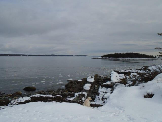
The location, amount and thickness of ice was assessed using information from the Canadian Ice Service, satellite images, regular site visits, and the marine forecast. Ice forms in the waters of the sanctuary site infrequently and, in recent years, only in small amounts by the shoreline. Furthermore, no pack ice was observed and the only ice found was slob ice (slushy sea ice) near the shore.

Photograph from standardized area (45.07843° -61.82626°) looking toward the mouth of the Bay/Barachois Island on 2020-02-17 showing small ice chunks along the western shore of the bay during the period of greatest ice cover.
Underwater Acoustics
We assessed the baseline underwater noise levels in the sanctuary site waters and the surrounding area to determine whether there are any sound levels that could interfere with echolocation and communication or otherwise cause any form of stress or discomfort for the sanctuary’s whale residents.
Broadband noise levels had an overall median of 92.57 dB re 1 µPa (range 89.03-146.77 dB re 1 µPa), with the ambient noise level at 89.78 dB re 1 µPa. Boats were present 13.6% of the time with a median of 97.42 dB re 1 µPa.
Orcas hear best between 4 and 100 kHz. For comparison, humans hear best between 32 Hz and 16 kHz. Noise levels were therefore weighted according to the hearing abilities of mid-frequency cetaceans (including orcas) to determine the broadband noise levels as they would be perceived by the sanctuary residents (overall median 86.24 dB re 1 µPa; ambient 85.85 dB re 1 µPa; boats present 87.04 dB re 1 µPa).
Temporary threshold shift (i.e., temporary hearing impairment) in mid-frequency cetaceans like orcas is thought to occur at 178 dB re 1 µPa, and permanent threshold shift at 198 dB re 1 µPa. Behavioral reactions can occur at lower levels, with 120 dB re 1 µPa being a common criterion for testing.
In sanctuary waters, underwater noise was typically within the 100 Hz to 1 kHz frequency range, at which orcas are less sensitive, occasionally extending to the lower (<100 kHz) and higher (>1 kHz) frequencies, which could be caused by environmental conditions such as wind/waves and rain. The amplitude of weighted broadband noise levels ranged from 85.72 to 132.17 dB re 1 µPa. Broadband weighted broadband noise levels exceeded 120 dB re 1µPa 0.03% of the time (total of 6 minutes out of 350 hours).
The above data indicate that the sanctuary waters present an excellent acoustic environment for orcas and would provide Wikie and Keijo the opportunity to explore their natural home through echolocation with little interference.
Hydrodynamic Model & Topography
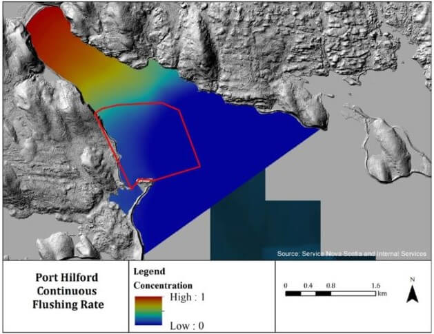
A hydrodynamic model integrates information about a specific water body to create a dynamic picture of water velocity and direction throughout the water column. It is important to have this information to understand the environmental conditions that the whales will experience, to provide physical oceanography data for sanctuary design and net placement, and to calculate water transfer rates to understand how storm debris and whale waste will move in the marine environment.
The results of a hydrodynamic model created by the Whale Sanctuary Project indicate:
- The sanctuary area is well flushed and will maintain a clean environment for the whales;
- There is a maximum water depth between 16-18 meters (52-60 feet);
- Land-based topography protects the sanctuary site from southeasterly storms.

Bathymetry with 2m contours calculated from multibeam survey (sanctuary perimeter net outlined in red).
Wave, Storm and Coastal Protection
Although the sanctuary site is on an ocean coastline, it is well protected from hurricanes and other high-magnitude storms. With storms that travel in a northwesterly direction (including most of the historic hurricanes that have reached the area), Barachois Island acts as a strong buffer against high winds and waves. Similarly, the high topography of the land area to the northeast of the site protects the sanctuary’s water space from the heaviest weather traveling from the northeast.
Data and evidence gathered before, during and after two recent hurricanes (Hurricane Teddy in September 2020 and Hurricane Fiona in September 2022) support these conclusions. During periods of heaviest storm activity, wave height was consistently lower in the sanctuary’s waters than in the open ocean.
In our experience relocating Keiko to Iceland, Keiko actively enjoyed experiencing the Icelandic storm weather, which was significantly rougher than the weather patterns along the Nova Scotian coast.
While some debris reaches the bay during and after storms, the bay pen and perimeter net are designed and constructed with materials (like 30–36-inch HDPE pipe) that can withstand such debris.
Marine & Land Ecosystems
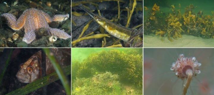
Additional multi-year surveys of the site and its surrounding region’s flora and fauna further indicate that this is an optimal environment for a marine sanctuary with no endangered plants or animals who would be impacted in the vicinity.
Dive surveys have found a richness of over 63 marine species, including 25 plants and algae, 29 invertebrates and 3 fishes. An overwintering bird survey identified 22 species.
Of note is the abundance of eelgrass in the sanctuary site’s waters. Eelgrass is a common bioindicator of ecological health demonstrating that the sanctuary constitutes a vibrant ecosystem with clean waters.

Biodiversity at the sanctuary site (Port Hilford Bay, Nova Scotia)